Density and population viability of coastal marten: a rare and geographically isolated small carnivore
A peer-reviewed article of this Preprint also exists.
Author and article information
Abstract
Pacific martens (Martes caurina) in coastal forests of Oregon and northern California in the United States are rare and geographically isolated, prompting a petition for listing under the Endangered Species Act. If listed, regulations have the potential to substantially influence land-use decisions and forestry on public and private lands, but no estimates of population size, density, and viability of remnant marten populations are available for evaluating their conservation status. We used GPS telemetry, territory mapping, and spatial mark-recapture to estimate population size and density within the current extent of Pacific martens in central Oregon, within coastal forest in the Oregon dunes national recreational area. We then estimated population viability at differing levels of human-caused mortality (e.g. roadkill). We estimated 63 adult martens (95% Credible Interval: 58-73) and 73 (range: 46-91) potential territories across two subpopulations separated by a large barrier (Umpqua River). Marten density was 1.02 per km2, the highest reported in North America. Using population viability analysis, extinction risk for a subpopulation of 30 martens ranged from 34% to 100% with two or more annual human-caused mortalities. Absent broad-scale restoration of forest to conditions which support marten populations, limiting human-caused mortalities would likely have the greatest conservation impact.
Cite this as
2017. Density and population viability of coastal marten: a rare and geographically isolated small carnivore. PeerJ Preprints 5:e3319v1 https://doi.org/10.7287/peerj.preprints.3319v1Author comment
This is a submission to PeerJ for review.
Sections
Supplemental Information
Bayesian modeling and example code
We used JAGS (Plummer, 2003) , accessed with the jagsUI package (Kellner, 2014) in R v. 3.2.3 (R Core Team 2016), to run the spatial mark-recapture analysis. Estimates were calculated from 4,500 MCMC samples, taken from 3 chains run for 5,000 iterations, thinned by 3, following a burn-in of 500. Below is the code we used to fit our spatial mark-recapture model with telemetry data to a population of coastal martens in central Oregon.
Supplemental summary of Pacific marten location data
Summary of location data collected by individual Pacific marten (Martes caurina). We collected spatial locations (Lxns) on marten when they were radio collared (Tracking period) with either a G10 snap technology GPS unit (27g, Advanced Telemetry Systems, “ATS”), a M1820 VHF unit made by ATS (27g; “VHF”), or a Quantum 4000 micro-mini GPS unit made by Telemetry Solutions (41-44g, “TS”). Location data were collected in the Oregon Dunes Recreation Area between October 2015 and January 2016. We estimated territories using 99% Local Convex Hulls (LoCoH) and here we report distance from territory center to the furthest edge of their territory (Radius).
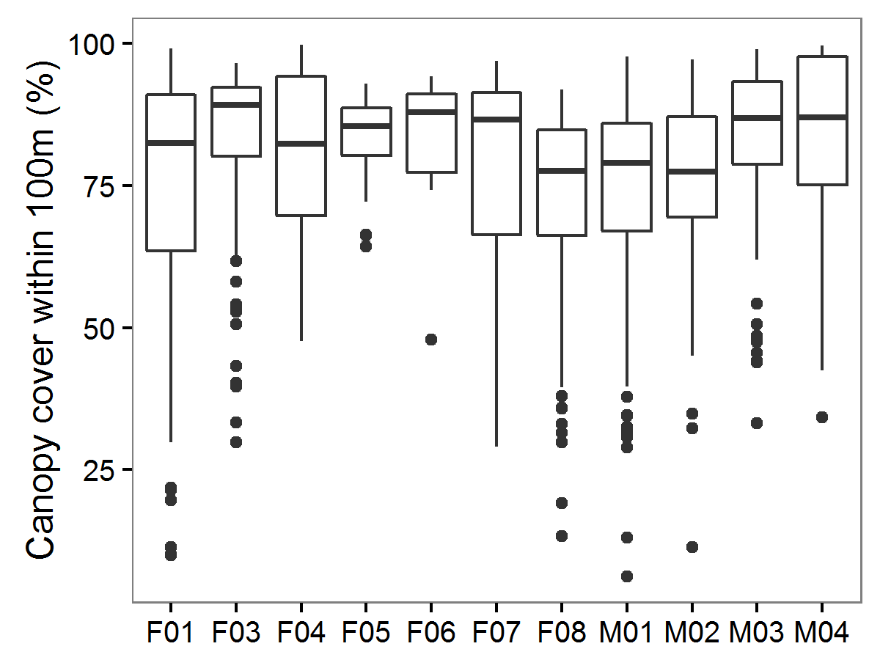
Percent cover associated with marten GPS locations in the Oregon Dunes
Percent forest cover (vegetation height >1 m estimated from LiDAR) within a 100 m moving radius of spatial locations collected using VHF and GPS telemetry of martens in coastal Oregon from October 2015 to January 2016. The average lower quantile combined with the demonstrated forested amount within home ranges were used to inform thresholds for territory mapping.
Supplemental meta-analysis of technical articles relating North American marten density and home range size
Technical articles that included the keywords “marten”, “density”, “territory”, and “home range”. Of the >75 papers reviewed for North American martens (Martes americana, M. caurina), four reported both home range sizes and density. Territories were estimated using either 100% Minimum Convex Polygons (MCP) or time-influenced Local Convex Hulls (t-LoCoH). Reported densities were either minimum known alive (MNKA) or calculated with spatial mark-recapture (SMR). Studies were conducted in Maine, USA (Payer and Harrison 1999), central British Columbia, Canada (Poole et al. 2004), New Hampshire, USA (Siren et al. 2016), and Quebec, Canada (Godbout and Ouellet 2010).
Additional Information
Competing Interests
The authors declare that they have no competing interests.
Author Contributions
Mark A Linnell conceived and designed the experiments, performed the experiments, analyzed the data, contributed reagents/materials/analysis tools, wrote the paper, prepared figures and/or tables, reviewed drafts of the paper.
Katie Moriarty conceived and designed the experiments, performed the experiments, contributed reagents/materials/analysis tools, wrote the paper, prepared figures and/or tables, reviewed drafts of the paper.
David S Green analyzed the data, contributed reagents/materials/analysis tools, wrote the paper, prepared figures and/or tables, reviewed drafts of the paper.
Taal Levi analyzed the data, contributed reagents/materials/analysis tools, wrote the paper, prepared figures and/or tables, reviewed drafts of the paper.
Animal Ethics
The following information was supplied relating to ethical approvals (i.e., approving body and any reference numbers):
The USDA Forest Service Institutional Animal Use and Care Committee provided approval for this research (Permit USFS 2015-002).
Field Study Permissions
The following information was supplied relating to field study approvals (i.e., approving body and any reference numbers):
We conducted research with live animals approved by Oregon Department of Fish and Wildlife Department Scientific Take Permit (ODFW 119-15).
Data Deposition
The following information was supplied regarding data availability:
Raw marten location data is not provided publicly due to the sensitivity of the species locations (e.g., Lindenmayer and Scheele 2017).
Lindenmayer D, and Scheele B. 2017. Do not publish. Science 356:800-801.
Funding
Survey efforts were funded by the USDA Forest Service Pacific Northwest Research Station, Siuslaw National Forest, and U.S. Fish and Wildlife Service’s Portland Office. The funders had no role in study design, data collection and analysis, decision to publish, or preparation of the manuscript.