Avian community structure and habitat use of Polylepis forests along an elevation gradient
- Published
- Accepted
- Subject Areas
- Biodiversity, Climate Change Biology, Conservation Biology, Ecology, Natural Resource Management
- Keywords
- Andean birds, Climate change, Conservation, Endemics, Threatened species, Mountain systems, Polylepis birds
- Copyright
- © 2016 Sevillano-Rios et al.
- Licence
- This is an open access article distributed under the terms of the Creative Commons Attribution License, which permits unrestricted use, distribution, reproduction and adaptation in any medium and for any purpose provided that it is properly attributed. For attribution, the original author(s), title, publication source (PeerJ Preprints) and either DOI or URL of the article must be cited.
- Cite this article
- 2016. Avian community structure and habitat use of Polylepis forests along an elevation gradient. PeerJ Preprints 4:e2570v1 https://doi.org/10.7287/peerj.preprints.2570v1
Abstract
Background. As one of the highest and most unique systems in the world, Polylepis forests are recognized both as center of endemism and diversity along the Andes and as a system under serious threat from human activities, fragmentation, and climate change. Effective conservation efforts are limited, in part, by our poor understanding of the habitat needs of the system’s flora and fauna.
Methods. In 2014-2015, we studied bird communities and 19 associated local and landscape attributes within five forested glacial valleys within the Cordillera Blanca and Huascaran National Park, Peru. Birds were surveyed in dry (May-August) and wet (January-April) seasons at 130 points distributed along an elevational gradient (3,300-4,700 masl) and analyzed using Canonical Correspondence Analysis (CCA).
Results. A total of 50 species of birds, including 13 species of high conservation concern, were associated with four basic habitat types: (1) Polylepis sericea forests at low elevations, (2) P. weberbaueri forests at high elevations, (3) Puna grassland and (4) shrublands. Four species of conservation priority (e.g., Poospiza alticola) were strongly associated with large forest patches (~10-ha) dominated by P. sericea at lower elevations (<3,800 masl), whereas another four (e.g., Anairetes alpinus) were associated with less disturbed forests of P. weberbaueri at upper elevations (>4,200 masl).
Discussion. Results suggest that, in addition to conserving large (>10-ha) P. sericea forests at lower elevations as the cornerstone for maintaining bird diversity, any high elevation (>4,200 masl) relicts of P. weberbaueri, irrespective of size, should be prioritized for conservation.
Author Comment
This is a submission to PeerJ for review.
Supplemental Information
Sevillano and Rodewald. 2016. Polylepis Birds Data Base
Axis scores based on Non-Metric Multidimensional Scaling NMMS based on 19 habitat variables
Score values greater than 0.5 are in bold.
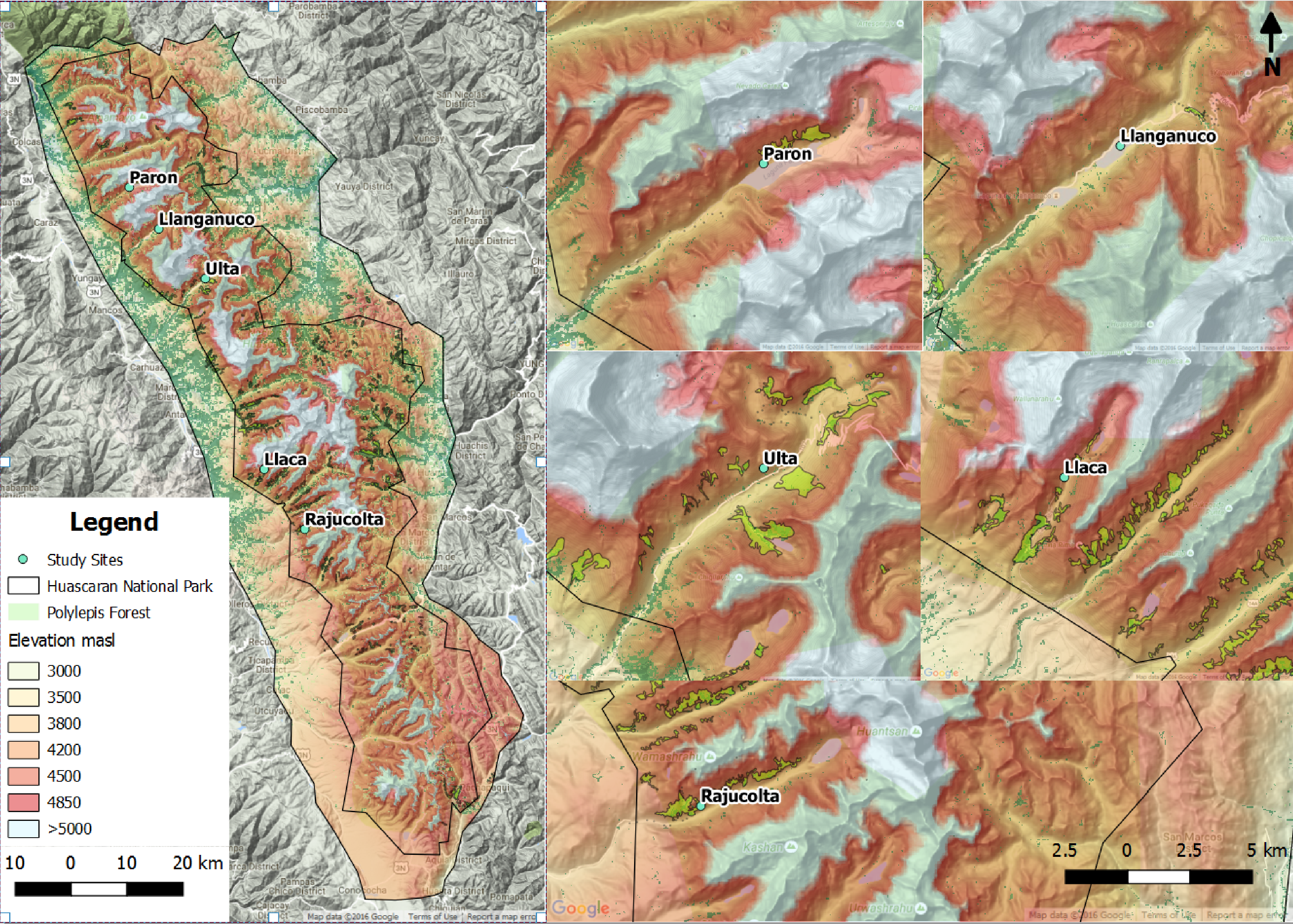
Location of study sites along the elevation gradient in Polylepis forest of Huascaran National Park, Peru
Five glacial valleys, Paron, Llanganuco, Ulta, Llaca and Rajucolta were surveyed for birds and habitat characteristics in 130 points from 3,300 to 4,700 msnl.
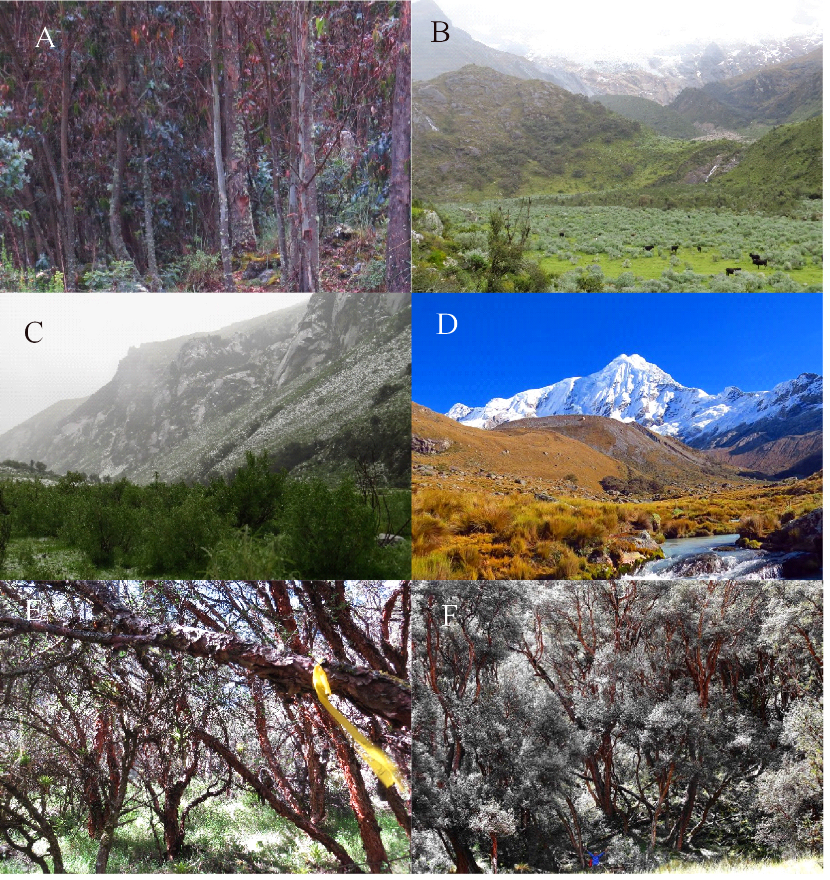
Vegetation communities located along an Andean elevational gradient
These include A) Eucalyptus forest usually at lower elevations, B-C) shrub areas dominated by Gynoxys/ Budleja/ Baccharis/ Lupinus species, D) Puna grassland areas dominated by Stipa ichu and E) Polylepis sericea woodland at lower and F) Polylepis weberbaueri at upper elevation.
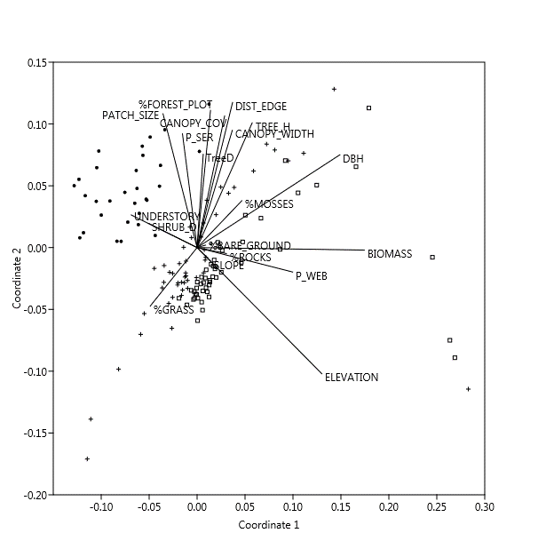
Non-Metric Multidimensional Scaling NMMS ordinations of 130 points based on 19 habitat and physical characteristics along a 2-dimensional axis coordinates
For visualization purposes, dot points represent locations below 3,800 m, cross points between 3,800 to 4,200 m and square points over 4,200 m in elevation.