
Impact of the catchment land use on some factors of lakes trophic status: a GIS approach
- Published
- Accepted
- Subject Areas
- Data Science, Spatial and Geographic Information Systems
- Keywords
- Land use, Catchment area, Corine Land Cover, QGIS, Conductivity, Secchi depth, Eutrophication
- Copyright
- © 2017 Sługocki et al.
- Licence
- This is an open access article distributed under the terms of the Creative Commons Attribution License, which permits unrestricted use, distribution, reproduction and adaptation in any medium and for any purpose provided that it is properly attributed. For attribution, the original author(s), title, publication source (PeerJ Preprints) and either DOI or URL of the article must be cited.
- Cite this article
- 2017. Impact of the catchment land use on some factors of lakes trophic status: a GIS approach. PeerJ Preprints 5:e2203v2 https://doi.org/10.7287/peerj.preprints.2203v2
Abstract
Background. Artificial enrichment of lakes has posed serious management problems for water supply. In results many European lakes had already undergone significant eutrophication. It seems that a good tool to determine the influence of catchment use on the trophic changes in lakes is Geographic Information System (GIS) and its databases.
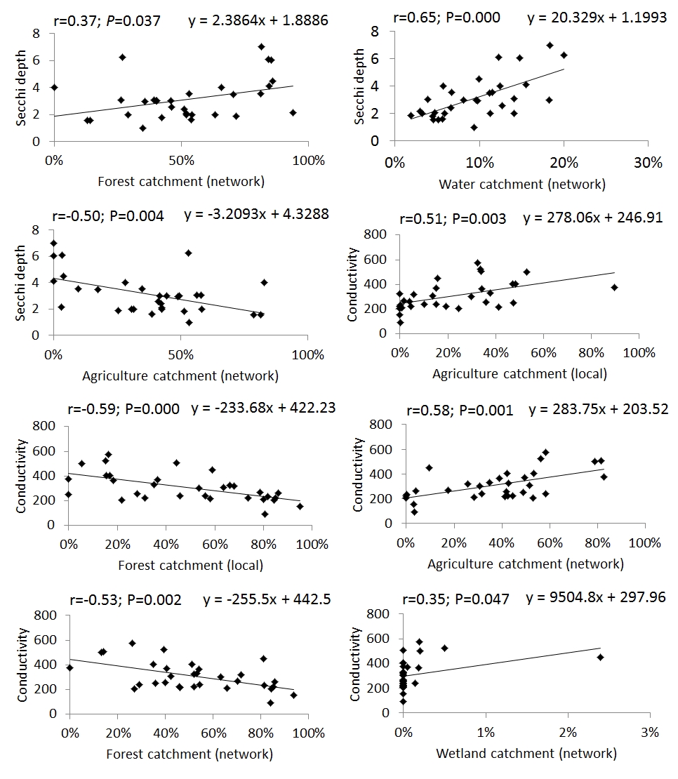
Methods. The study covered 31 stratified lakes located in northwestern Poland. These lakes were chosen on account of their considerable recreation value and economic importance. The parameters chosen as dependent variables were Secchi depth and electrical conductivity. Local catchments and network catchment of studied lakes as independent variables were prepared using QGIS Wien (2.8.7). The land use variables were prepared with Corine Land Cover, 2006 (CLC2006).
Results. According to Carlson index the studied lakes ranged from mesotrophic to eutrophic. Both dependent variables Secchi depth and conductivity values were significantly correlated with independent land use variables (P < 0.05).
Discussion. Our survey revealed that percentage use of the catchment (developed in the Geographic Information System) can be a useful tool in the assessment of the lakes risks. With the GIS tools we also confirmed a significant impact of land use on changes transparency and conductivity values in North West lakes in Poland.
Author Comment
The formatting of the text has been changed in accordance with the suggested pattern (OGRS2016).