Seasonal dynamics of terrestrial vertebrate abundance between Amazonian flooded and unflooded forests
- Published
- Accepted
- Subject Areas
- Conservation Biology, Ecology, Natural Resource Management
- Keywords
- camera-trapping, flood pulse, floodplain dynamics, wetlands, várzea, seasonal movements
- Copyright
- © 2018 Costa et al.
- Licence
- This is an open access article distributed under the terms of the Creative Commons Attribution License, which permits unrestricted use, distribution, reproduction and adaptation in any medium and for any purpose provided that it is properly attributed. For attribution, the original author(s), title, publication source (PeerJ Preprints) and either DOI or URL of the article must be cited.
- Cite this article
- 2018. Seasonal dynamics of terrestrial vertebrate abundance between Amazonian flooded and unflooded forests. PeerJ Preprints 6:e26960v1 https://doi.org/10.7287/peerj.preprints.26960v1
Abstract
The flood pulse is the main factor structuring and differentiating the ecological communities of Amazonian unflooded (terra firme) and seasonally-flooded (várzea) forests as they require unique adaptations to survive the prolonged annual floods. Therefore, várzea and terra firme forests hammer out a spatio-temporal mosaic of resource availability, which may result in landscape scale seasonal movements of terrestrial vertebrates between adjacent forest types. Yet the lateral movements of terrestrial vertebrates between hydrologically distinct neighbouring forest types exhibiting staggered resource availability remains poorly understood, despite the important implications of this spatial dynamic for the ecology and conservation of forest wildlife. We examined the hypothesis of terrestrial fauna seasonal movements between two adjacent forest types at two contiguous sustainable-use forest reserves in Western Brazilian Amazonia. We used camera trapping data on the overall species richness, composition, and abundance of nine major vertebrate trophic guilds to infer on terrestrial vertebrate movements as a function of seasonal changes in floodplain water level. Species richness differed in neighboring terra firme forests between the high-and low-water phases of the flood pulse and terra firme forests were more species rich than várzea forests. There were clear differences in species composition between both forest types and seasons. Generalized Linear Models showed that water level was the main factor explaining aggregate abundance of all species and three trophic guilds. Our results indicate that the persistence of viable populations of large terrestrial vertebrates adjacent to major Amazonian rivers requires large, well-connected forest landscapes encompassing different forest types to ensure large-scale lateral movements by forest wildlife.
Author Comment
This is a submission to PeerJ for review.
Supplemental Information
Camera trap raw data
Number of detections of 25 terrestrial vertebrate species recorded across the middle Juruá region in unflooded and flooded forests
Camera trap raw data metadada
Abbreviations and Linnean binomials of 25 terrestrial vertebrate species recorded across the middle Juruá region in unflooded and flooded forests
Camera trap variables
Landscape and human disturbance variables extracted from 279 camera trap stations in the middle Juruá region, Amazonas, Brazil.
Camera trap variables metadata
Abbreviations and description of landscape and human disturbance variables extracted from 279 camera trap stations in the middle Juruá region, Amazonas, Brazil.
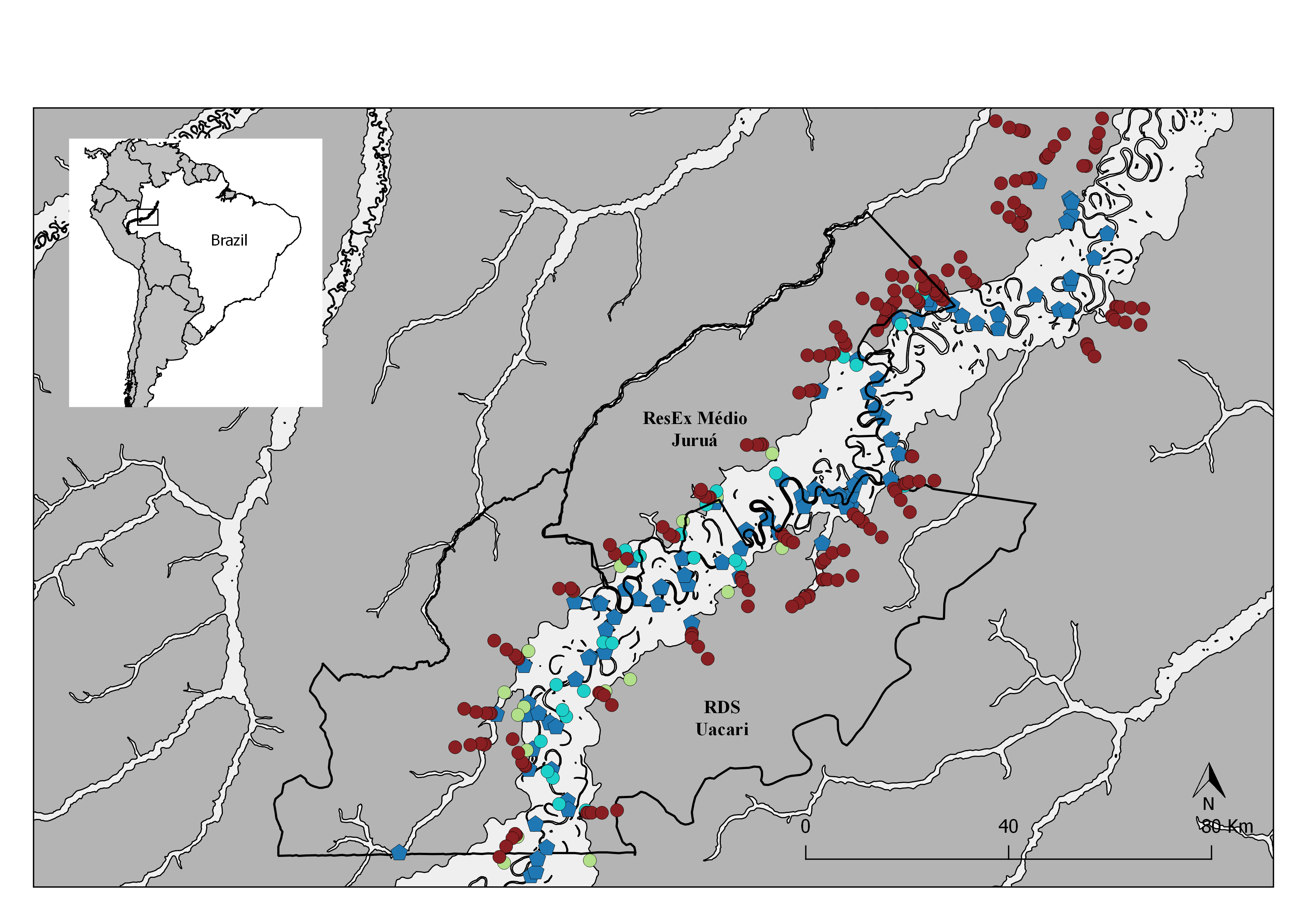
Fig S1. Map of the study area in the central Rio Juruá region of western Brazilian Amazonia, Amazonas, Brazil
Map inset shows the geographic location of the Juruá river and study region. The boundaries of the RESEX Médio Juruá and RDS Uacari are outlined in black. Seasonally flooded forests and terra firme forests are represented in light and dark gray respectively. Solid red circles represent camera trap stations (CTS) deployed radiating inland into terra firme forest (sample design 1). Green and aqua circles represent CTS deployed at terra firme forest sites near forest habitat boundaries along the várzea interface and far into várzea forest, respectively (sample design 2). Blue pentagons represent the location of human settlements.