Crowdsourcing with mobile techniques for crisis support
- Published
- Accepted
- Subject Areas
- Databases, Social Computing, Spatial and Geographic Information Systems
- Keywords
- natural processes, crowdsourcing, mobile, citizens and volunteers
- Copyright
- © 2016 Frigerio et al.
- Licence
- This is an open access article distributed under the terms of the Creative Commons Attribution License, which permits unrestricted use, distribution, reproduction and adaptation in any medium and for any purpose provided that it is properly attributed. For attribution, the original author(s), title, publication source (PeerJ Preprints) and either DOI or URL of the article must be cited.
- Cite this article
- 2016. Crowdsourcing with mobile techniques for crisis support. PeerJ Preprints 4:e2274v2 https://doi.org/10.7287/peerj.preprints.2274v2
Abstract
The responsibilities deployed from the central authorities to local levels acting as first actors of civil protection are a changing pattern in natural hazard management. Prevention and preparedness are long-term goals, rooted in the competence of volunteers, and on the awareness of the citizens as local inhabitants. MAppERS (Mobile Application for Emergency Response and Support) relies on people as “crowd-sourced mappers” through mobiles application. The feedback received from testing and training courses aims to raise participation in a networked disaster response. The goal was to design a mobile application with a real-time dashboard for public citizens and volunteers of civil protection. Two pilot study cases were selected that included trainings on modules, verification of the usability and the quality of the product. The synchronized platform shows the activity of the cloud data collection with a central data dashboard. A first section of the application focuses on floods processes by gathering data from local population, and contributes to awareness and long-term preparedness. The second section of the application tests pre-emergency actions on field with rescue teams, collecting the condition of the hazards.
Author Comment
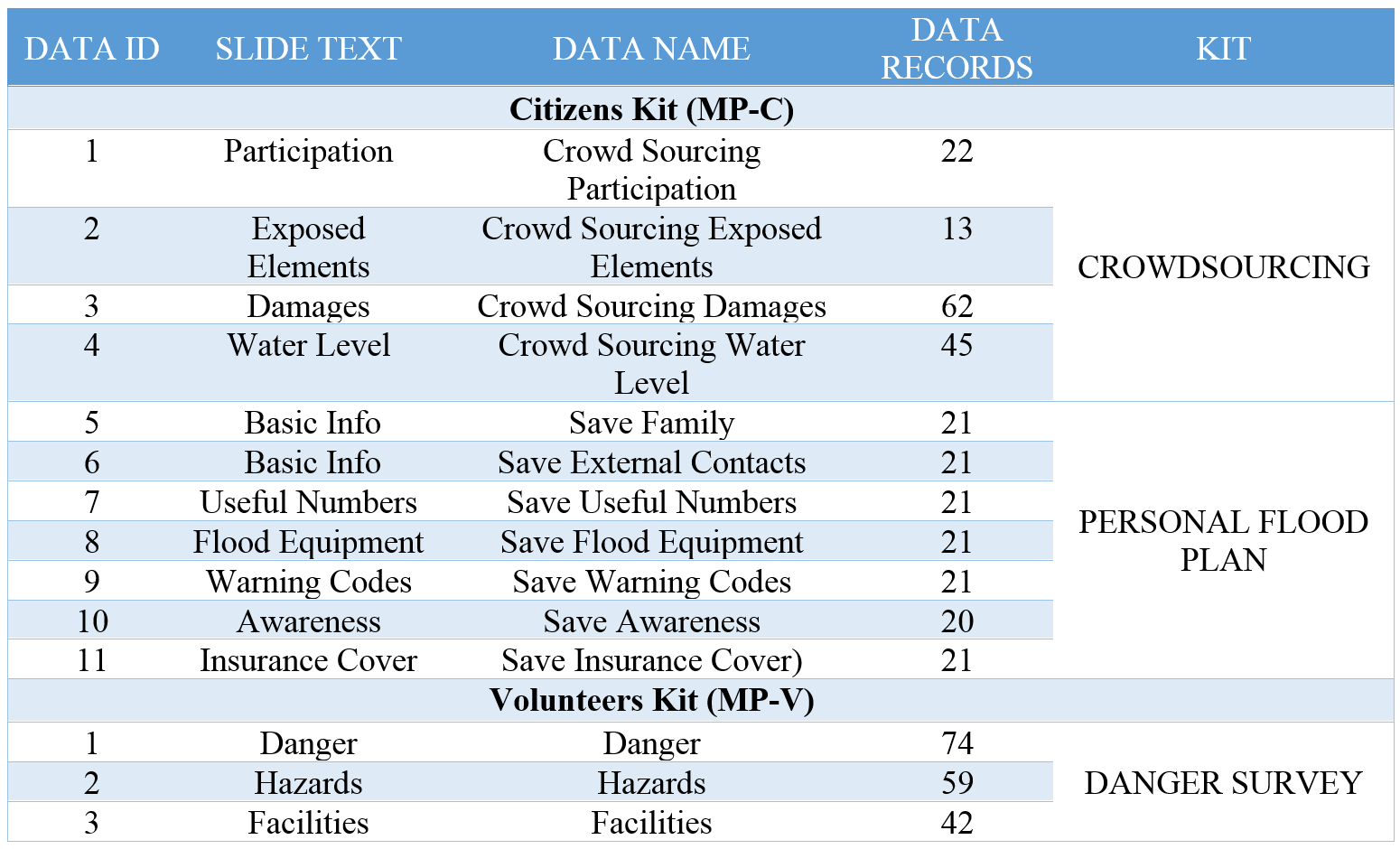
The new version includes reviews proposed. Conclusions and perspectives embrace more explanations of results and follow up obtained. Table 1 describes the output within piloting, clarifying updates and customization achieved. The paragraph highlights advantage of crowdsourcing, limits of technology with critical evaluation and output obtained. We illustrate the approach assumed with architecture and service. All modules link initially services and modules, and furthermore explained in the study areas.
Map data © 2016 Google is included in Figure 3, as specified by the Attribution Guidelines for Google Maps and Google Earth. We submitted the paper to a native English, to update and review language. Figures focus now on specific modules of mobile applications, while Table 1 lists the results of piloting activities with end-users.