Summer Heat Risk Index: how to integrate recent climatic changes and soil consumption component
- Published
- Accepted
- Subject Areas
- Data Science, Spatial and Geographic Information Systems
- Keywords
- climate changes, ISPRA, Soil Consumption, Summer Heat Risk Index, CNR, urban heat risk
- Copyright
- © 2017 Crisci et al.
- Licence
- This is an open access article distributed under the terms of the Creative Commons Attribution License, which permits unrestricted use, distribution, reproduction and adaptation in any medium and for any purpose provided that it is properly attributed. For attribution, the original author(s), title, publication source (PeerJ Preprints) and either DOI or URL of the article must be cited.
- Cite this article
- 2017. Summer Heat Risk Index: how to integrate recent climatic changes and soil consumption component. PeerJ Preprints 5:e2234v2 https://doi.org/10.7287/peerj.preprints.2234v2
Abstract
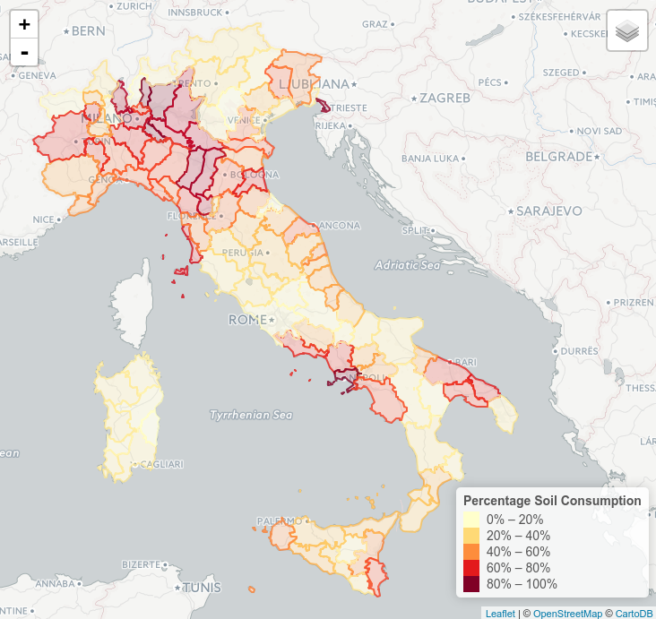
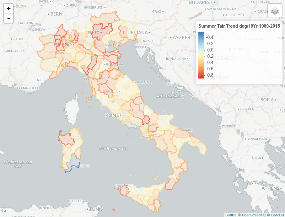
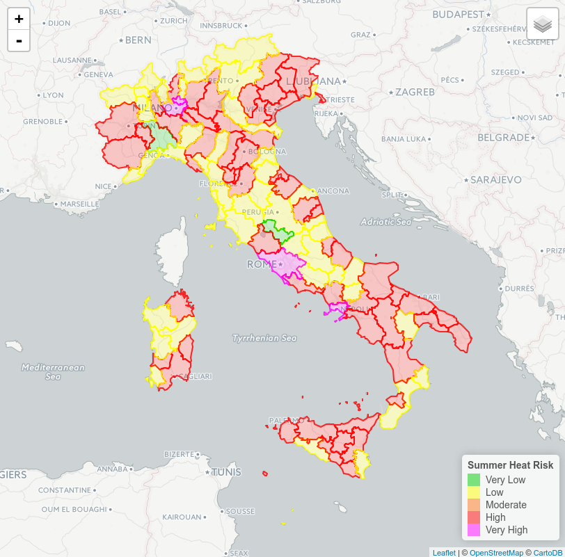
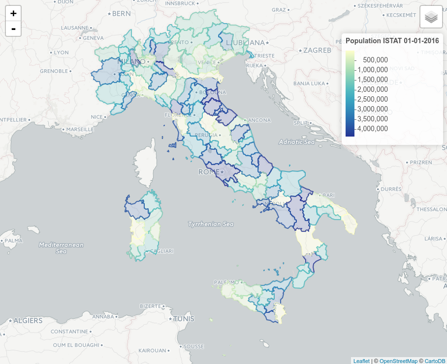
Face to the urban resiliency two major environmental threats are widely recognized: the increasing summer air temperatures and the soil consumption that affects a large number of city in Italy. The work have the goal to present preliminary the actual Heat Summer Risk defined by using Crichton's Risk Triangle (Crichton, 1999) on the second Italian level of administration (ADM2 - Province). For each administrative unit we have considered as hazard layer the most recent trend of summer air temperature assessed (1980-2014); the exposure layer is individuated by the amount of population living in each province and finally as vulnerable layer the mean degree of soil consumption expressed in percentage was considered. Thanks to these information Crichton's methodology are able to give a quantitative risk value index further classified in five risk class. Data sources was provided by several authoritative institutions : (i) ISPRA ( Italian National Institute for Environmental Protection and Research) that provide data about density of soil consumption for 2015 as reported in the Soil Consumption Report 2016; (ii) ECAD (European Climate Assessment \& Dataset) that gives detailed historical daily climatic layers (E-OBS 1950-2015 v 13.0); (iii) ISTAT ( Italian National Institute of Statistics) that provides the last updates on Italian population data (2016). The results was mapped and presented. All computations was carried out in R-STAT environment by using different library available for Spatial and Trend Analysis. Data and code are released in public repository.
Author Comment
i have update the mail for correspondent author and Openstreetmap citation of figures in manuscript.